So fellow travelers, it is almost time to hit the trails of Robert Treman State Park.
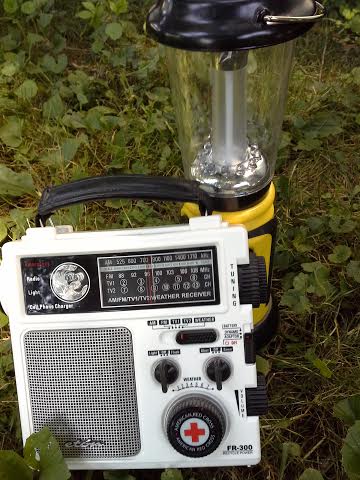
The next morning my trusted weather radio chirped bright and early, alerting me to a “slow moving front, descending across the Great Lakes.” RTSP is about 80 miles as the crow files from the southern shores of Lake Ontario. There’s good reason SUNY’s Meteorology program is located at the Oswego campus and boosts reknown alumni like Al Roker. ( Jerry Seinfeld is also a SUNY Oswego alumnus; yes classmates, no they didn’t hang out together. ) One can watch storms form out of apparent thin air and roll onshore with impressive speed and force. Camping by Lake Ontario ( Southwick State Park is my other must-camp pick) has honed my interpretive skills in deciphering NOAA weather reports. (Sometimes I think I missed my calling, but back in my college years women were “weather girls,” not meteorologists.)
Sitting by the embers of last nights fire, watching steam rise from both my breath and my coffee I listened intently to the forecast and did some calculations. The two trails which run along the gorge in RTSP are about a 5 mile round trip hike. On flat ground that would take me just under two hours. However, the Rim and Gorge trails are two of the three trails ranked most difficult in the NYState Park system, outside the High Peaks of the Adirondacks. Oh the third most difficult trail? Buttermilk Falls, located three miles up the road back to Ithaca. No matter how you hike them, the Rim and Gorge trails require extra time. In fact many park visitors drive up the paved road to Enfield Glenn and walk the short half mile down to see Lucifer Falls which is the main attraction of the Gorge Trail.

Enfield Glenn, runner up wedding site ( the pavilion was too small)

Lucifer Falls (to get a sense of scale, look closely for the people standing just to the right where the falls start )
My usual routine is hiking up the less picturesque Rim Trail, which provides good birding spots spaced at just the right intervals for catching one’s breath. Towards the upper end of the trail there are several points where you can access the river, perfect spots for trail snacks and cooling off. Since the Rim Trail is less popular, I find I am more likely to have these spots to myself. Refreshed I would then hike a few minutes up to the bridge which crosses over to the Gorge Trail. From there is it about a quarter mile up to Lucifer Falls and currently the only way to reach the falls as a notice at the camp office indicated the upper portion of the trail was closed for repairs. Traveling the Gorge Trail provides more photo ops and river access points which is why I like to make it my return route. It makes for a more leisurely hike, a reward for the effort of mastering the Rim Trail.
Taking potential rain into account, it definitely made more sense to hike the Rim Trail up and the Gorge Trail back down. The Rim Trail is mostly dirt, lots of tree roots cross the path; it becomes a slippery muddy mess in heavy rains. The Gorge Trail is better groomed with long sections of stone paths and good solid stairs. Anyway, the line of storms was forecast to arrive mid to late afternoon and my plan was to be back at camp by then.
Mother Nature it turned out had other plans.
to be continued…..
Walk gently on the path my friends and may adventure find you ready.